
Additional Information
- Rainfall
- Ground Cover
- Groundwater
- Eco Calculation
- Fish
- Fish Barriers
- Floods
- Land Use
- Marine Condition
- Pesticides
- Reef Check
Ground Cover
| Catchment | Result |
|---|---|
| Callide | 84 % |
| Comet | 81 % |
| Connors | 91 % |
| Fitzroy | 90 % |
| Lower Dawson | 85 % |
| Lower Isaac | 83 % |
| Mackenzie | 83 % |
| Nogoa | 82 % |
| Theresa | 79 % |
| Upper Dawson | 85 % |
| Upper Isaac | 82 % |
Ground Cover
The above map shows the average groundcover for each catchment
Ground cover refers to any attached or detached organic material on the soil surface or material up to half a metre from the soil surface that acts to reduce the impact of a raindrop on the surface of the soil. High ground cover reduces the erosive forces of rain, anchors soil in place, increases infiltration, and reduces runoff and the spread of contaminants. In turn, this contaminant reduction minimises the impact on downstream asset
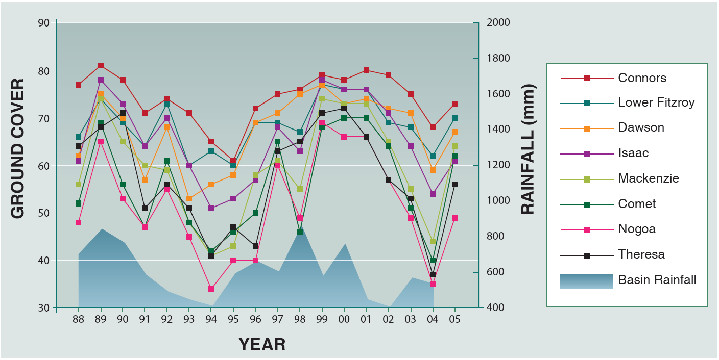
Analysis shows that during drought mean cover can drop below 50% at a sub-basin scale. Mean cover is lower for the western catchment owing to a lower average rainfall. The Nogoa sub-basin has the lowest mean cover, due to cropping and low cover on grazing land. By comparison, the Connors River catchment has the highest mean cover. At less than 30% mean ground cover, open cut coal mines have the lowest cover of any land use category, followed by cropping, then grazing.
There is a strong correlation between annual rainfall and mean ground cover across Central Queensland. The main impediment to high cover, apart from seasonal influences, comes from land management practices. There is also variation in ground cover trends between land types indicating that although seasonal condition is the main driver of ground cover, certain land types are more resilient to grazing pressure and dry conditions whilst others are more susceptible.
Correlation between ground cover and rainfall in the Fitzroy Basin.
 Source: Fitzroy Water Quality Improvement Report
Data Source: Queensland Bare Ground Index
Source: Fitzroy Water Quality Improvement Report
Data Source: Queensland Bare Ground Index