

[wqip-tabs]
The Fitzroy Water Quality Improvement Plan (WQIP:2015) has been developed to improve water quality in the Fitzroy Basin to protect the Great Barrier Reef.
WQIP:2015 covers the Fitzroy Basin and coastal catchments (Styx, Shoalwater, Water Park Creek, Boyne and Calliope) as well as adjacent marine waters. The plan sets water quality targets for the region, identifies priority areas to undertake works and recommends management actions to improve water quality. It will guide investments in our region to improve water quality and help restore the health of the Reef.
Community members, stakeholders, governments, and industry groups are all encouraged to provide comments and feedback on the WQIP:2015. You can provide feedback by leaving comments here.
Select each of the links below in the diagram to explore what is in WQIP:2015, how our plan was formed and what it will be used for.
What…
The Fitzroy Water Quality Improvement Plan (WQIP:2015)—this website—shows how we can improve regional water quality to protect our waterways and ultimately the Great Barrier Reef. WQIP:2015 sets out the priorities for improving water quality, including: describing the coastal and marine ecosystems and species that are at risk from poor water quality; identifying catchment ‘hot spots’ of soil erosion and nutrient run-off that are the source of water quality problems; understanding how land management practices and habitat restoration can reduce the risk of water quality problems; and finding the most cost-effective ways to reduce water quality risks.
WQIP:2015 includes water quality targets that set the standard for improvements that could be achieved in the next five years.
Where…
The Fitzroy Basin covers an area twice the size of Tasmania, about 152,000 km2. We have eight sub-catchments in our region and these include the Lower Fitzroy, Isaac-Connors, Comet, Upper and Lower Dawson, Styx-Herbert, Water Park and Boyne-Calliope sub-catchments. This equates to over 20,000 km of waterways and over 7,000 wetlands. Logistically this is a vast area to cover and FBA has decided to further split this area into what we call “Neighbourhood Catchments” or NCs for short. There are 192 NCs and each is a mini catchment concerning local people who understand and care about the place they live. The boundaries for the NCs can be viewed below with some interactive mapping to explore where you are.
How…
WQIP:2015 was developed through engagement with scientists, consultants, local experts, regional stakeholders and government agencies. It uses the best available science and incorporates the findings of 12 supporting studies that were commissioned as part of the plans development. These studies, along with a summary synthesis document, can be viewed here.
The below conceptual diagram details how the Fitzroy WQIP:2015 was developed, how the scientific evidence was integrated and how it will be used.
Who…
FBA has spent over 12 months undertaking activities that have informed WQIP:2015. Scientists and experts have been involved in collating, analysing and communicating important information to determine what needs to be done to improve water quality. We thank all parties involved in developing the science behind WQIP:2015. A list of the people involved can be found below.
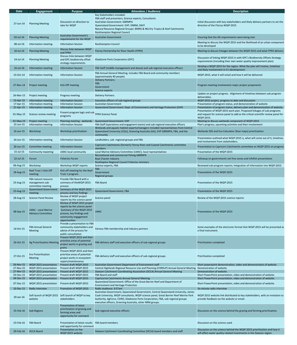
Partner groups, government, industry stakeholders and the community have all been approached at different times to contribute to WQIP:2015. Refer to the table below for details on participants to date.
Why…
The objective of WQIP:2015 is to improve the health of the region’s waterways by identifying and prioritising actions to restore ecosystems and reduce water quality issues. A series of water quality, land and catchment management targets have been set to measure the outcomes of activities implemented under the plan. More information can be found below.
[contentblock id=starfish-selector]